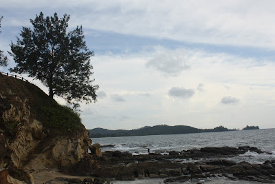
The island of Borneo is the third biggest island in the world, divided between three countries; Indonesia, Brunei and Malaysia. The Malaysian part of the island is made up of two different states, Sabah and Sarawak.
Sabah is located in the northernmost part of the island of Borneo. In the northern-most part of the northern-most land of Sabah is the Kudat peninsula. These are the lands of the Rungus people; one of the many tribal groups in Sabah.
The Kudat peninsula juts out like a finger and eventually terminates at Tanjung Simpang Mengayau, the northern-most point of the island of Borneo. Tanjung Simpang Mengayau is the modern malay name for the Tip of Borneo, and is derived from the Rungus name Tanjung Sampang Mangazou.
In the Rungus language, "Tanjung" means "Tip" or "Cape"; "Sampang" means "Junction" and "Mangazou" means "Battle". This alludes to the fierce battles the Rungus fought at this Cape at the Junction of the South China Sea and the Sulu Sea, to defend their homeland against pirates and invaders.
Today, the Tip of Borneo is no longer the site of battles; but now has become the focus of tourists who come to this cape to say that they have reached the northern-most part of the island of Borneo and to come and witness the point where the waters of the South China Sea clashes with the water of the Sulu Sea.
It is here that you can also witness why Sabah is known as the Land Beneath the Wind, as the winds drive the waters of the South China Sea crashing against the rugged headland.
The nearest major town to the Tip of Borneo is Kudat. Kudat was the former first capital of British North Borneo (the predecessor of Sabah), before the capital moved to Sandakan and then to the present capital of Kota Kinabalu. Today Kudat has the feeling of being just a small frontier town, but it does have a small airport. From Kudat it is just a short drive to the Tip.
Where the roads were once just gravel, the road to the Tip has now been fully sealed, although there are still the odd bumpy sections and under repair as is usually the case in Sabah. There is also still an alternate gravel road and some of the signage can be confusing as it will direct you to the gravel road instead of the sealed one.
Eventually though you will reach the pretty Kalampunian Beach with the Tip of Borneo headland visible in the distance. As you drive along the seaside road, you will pass by Rungus stalls selling sea-shells and a couple of chalet accommodation.
 |
| The waves of the South China Sea on Kalampunian beach. |
The road then climbs up the headland where you come to an open-air carpark adjacent to two chalet accommodation options, the cheaper Simpang Mengayau Chalets and the dearer TSM Merrimas Villas. Park you car here, there is no car-parking or admission fees; you can then stop for a drink at the restaurant of the Simpang Mengayau Chalets which is located overlooking the calm waters of the Sulu Sea.
 |
| The calmer waters of the Sulu Sea on the other side of the peninsula. |
After your drink, you will have to walk the rest of the way to the Tip. Stop first at the viewing platform and look back at the marvelous view to Kalampunian beach.
 |
| Kalampunian beach viewed from the Tip. |
Continue your walk down then up the road to where the Globe and Flag is. The Globe shows you exactly where you are on the map of the region.
Walk to the far end of the headland, and you will see steps leading down the hill to the rocks below. Walk down the steps until it ends at a barrier with a warning sign not to proceed further. Look down at the slivers of rock below which jut out into the sea, marking the end of the island of Borneo.
If you are daring, you can clamber down to the rocks below - do this at your own risk, it can be dangerous.
Admire the weird nooks and crannies that the waves have created in the rocks as the waves crash all around you.
Return back up to the top of the headland and wait for the sun to descend into the waves, painting the sky and the sea golden amidst the pounding waves and the whistling breeze. This is the Tip of Borneo!


No comments:
Post a Comment